
Getting around a city that’s laid out in a square is certainly easier. Now you can see which cities are the least rigid in their design.


Manhattan’s street grid is the savior to many a lost tourist, but navigating it also requires that New Yorkers re-orient the world around themselves (what else is new?). That’s because the grid pattern is off-kilter. So when a New Yorker gives directions by saying head north on 6th Avenue, what they actually means is head northeast, at least in orientation to everywhere that is not on the island of Manhattan.
This quirk is apparent in an interesting set of visualizations that display the relative dominance of the North-South-East-West grid pattern within the road networks a handful of cities and counties in the U.S. and Europe. The work, which is designed to show an average of the entire road network, is the creation of Seth Kadish, an Oregon-based data visualization enthusiast who posts his creations on his blog, Vizual Statistix.
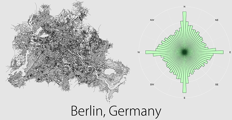
Some cities deviate from the grid because of topography or bodies of water that get in the way. In others, urban planners may have just not appreciated the beauty and efficiency of a simple grid. The streets of older cities, especially in Europe, were likely set long before urban planning was a thing at all.
The streets of European cities, including London, Paris, Berlin and Madrid, had barely a grid at all compared to large U.S. cities. Cities like Chicago, Denver, Salt Lake City, Detroit, Houston, Washington, D.C., and even Los Angeles have dominant grids, as do New York and Philadelphia—though as noted earlier, the latter two are slightly skewed. Kadish notes that Manhattan is particularly interesting because streets running the width of the island dominate the number running the length.
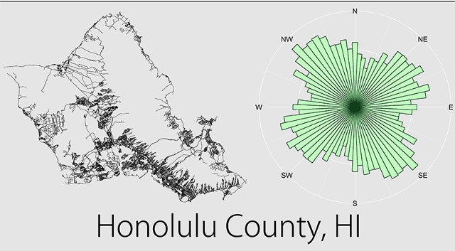
Of the U.S. cities he looked at, Honolulu and the two counties that include Charlotte, North Carolina, and Pittsburgh deviate the most from the grid, with streets sprawling out every which way, favoring no particular direction. New Orleans, San Francisco, St. Louis, and Boston have some gridded patterns but also have many roads rotated in other directions.
All of this work gave Kadish a bit of time to reflect on the merits of different visions for street layouts.
«Personally, I think it’s great that some cities deviate from the modern grid. I’m happy to be living in a gridded city (Portland, Oregon), because I find it makes navigation much simpler. Particularly for driving, the grid plan is less confusing and usually more efficient. That said, if all cities followed the same format, it would make traveling and exploration much less exciting. Additionally, deviations from a grid allow for roads that follow winding rivers and curve around topography. Those types of features can often be much more inviting than the ability to make a 90-degree turn at any intersection,» he says.
Fuente: CO.EXIST – JESSICA LEBER